It was sunny in the morning I left for my hike up Bukit Timah Hill. Singapore doesn't have major mountains or hills, but Bukit Timah hill is the highest point on Singapore, at an altitude of 163 metres from sea level. When I reached Beauty World MRT station, the closest MRT station to BT hill, and went up the escalator, I saw water flowing down the glass panelled roof. For a moment, I was convinced that it was some sort of fountain. I told myself, no, it cannot be raining. But when I finally arrived on the street level, I realised that it was raining frogs and fishes. I was dejected, and surprised, because it had been so sunny when I had left. In such places where tropical rainforests are abundant, it rains very often as the air is very humid. I had no choice but to wait at Beauty World mall till it subsided, which, after a good two hours, it finally did.
I took the overhead bridge leading to Bukit Timah park, where the Hill also is (it took me a while to locate the entrance, which is beyond the church). I could see the tall radio stations from the top of the hill, covered with mist, from the overhead bridge itself. I walked inwards into the park, but it was a bit confusing as I felt there was a lack of signboards - an unusual thing since Singapore has done an excellent job of placing signboards everywhere - and I thought I was losing my way, even despite following my GPS. To make the long story short, I was indeed walking the wrong way, but luckily a passer-by pointed me in the right direction and I found myself at the foot of the hill shortly. Here onwards, there is no dearth of signboards. If you are coming to this place, keep walking straight from after turning right of the church.
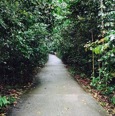
The beginning looked something like this. It was raining slightly and very few people were there.
I took the overhead bridge leading to Bukit Timah park, where the Hill also is (it took me a while to locate the entrance, which is beyond the church). I could see the tall radio stations from the top of the hill, covered with mist, from the overhead bridge itself. I walked inwards into the park, but it was a bit confusing as I felt there was a lack of signboards - an unusual thing since Singapore has done an excellent job of placing signboards everywhere - and I thought I was losing my way, even despite following my GPS. To make the long story short, I was indeed walking the wrong way, but luckily a passer-by pointed me in the right direction and I found myself at the foot of the hill shortly. Here onwards, there is no dearth of signboards. If you are coming to this place, keep walking straight from after turning right of the church.
The beginning looked something like this. It was raining slightly and very few people were there.
I wouldn't say the incline is too steep. At one point close to the bottom of the hill, the ground inclines sharply, almost 60 degrees, and you need to walk slowly and carefully. After that, the climb up should be largely smooth. It gets very humid and misty as you go up; make sure you have a towel with you to clean your specs if you wear them. It was wonderfully serene walking up the hill - it was dark, misty and rainy, no one was around, I was surrounded by rainforest sounds like birds chirping and the faint rustling of trees.
At this point I must warn you about the forest animals. The variety includes - but is not limited to - lemurs, squirrels (I spotted two!) and monkeys. I heard monkeys squealing their wild calls in the forest on my left as I was coming down the hill, and I was freaked out. After my encounter with monkeys in Vrindavan, I was worried of monkeys attacking or stealing my glasses, which I cannot see even 10 centimetres without. But luckily, no monkey came in my path throughout my expedition. I had read reviews and blog posts before I went to BT hill, and I didn't see any reports of monkeys stealing caps or glasses, though you will see signboards on the hill itself warning you not to feed any monkeys. I guess Singaporean monkeys are more well-behaved than Indian monkeys.
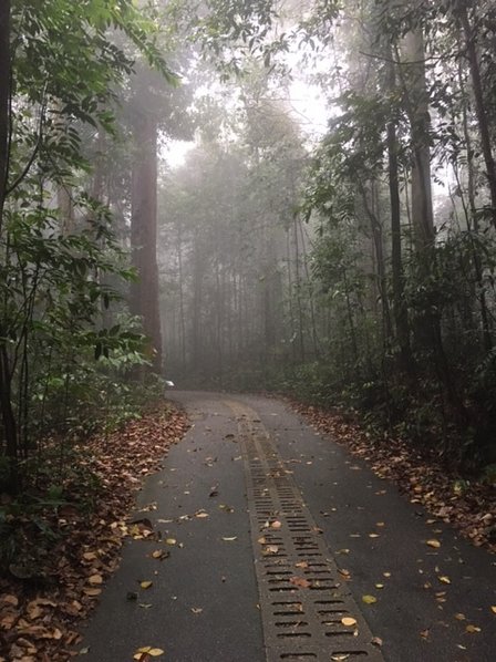
This is how it looked as I entered the cloud forests of BT hill:
At this point I must warn you about the forest animals. The variety includes - but is not limited to - lemurs, squirrels (I spotted two!) and monkeys. I heard monkeys squealing their wild calls in the forest on my left as I was coming down the hill, and I was freaked out. After my encounter with monkeys in Vrindavan, I was worried of monkeys attacking or stealing my glasses, which I cannot see even 10 centimetres without. But luckily, no monkey came in my path throughout my expedition. I had read reviews and blog posts before I went to BT hill, and I didn't see any reports of monkeys stealing caps or glasses, though you will see signboards on the hill itself warning you not to feed any monkeys. I guess Singaporean monkeys are more well-behaved than Indian monkeys.
This is how it looked as I entered the cloud forests of BT hill:
Now, there is a lot of history associated with BT hill. Due to its strategic location, it was used as a hide-out by the soldiers of Singapore as well as by the incoming Japanese soldiers during World War II. In fact, even tigers prowled these forests once, but after the Governement had introduced rewards for people who killed these tigers back in the 1900s, the tiger population became extinct.
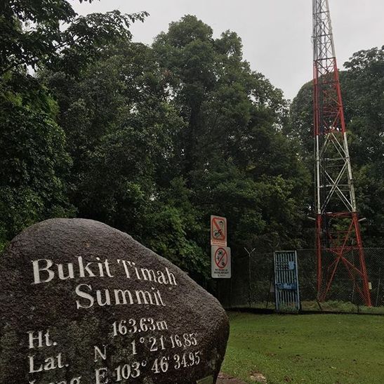
I used the normal route, but there are several other trails you will see signboards for, like, Rocky Trail, and so on. You can follow them if you want, but they will be much more tricky and may be closed for repairs or during inclement weather. If you want to keep to the normal route, just follow the path that leads on to 'Summit (so-and-so metres)'. After around 25 minutes, I reached the summit. I don't want to spoil it for you so I won't show all the photos of the summit, but this is the mark of the completion of your upward hike and you will see it when you reach the top:
I used the normal route, but there are several other trails you will see signboards for, like, Rocky Trail, and so on. You can follow them if you want, but they will be much more tricky and may be closed for repairs or during inclement weather. If you want to keep to the normal route, just follow the path that leads on to 'Summit (so-and-so metres)'. After around 25 minutes, I reached the summit. I don't want to spoil it for you so I won't show all the photos of the summit, but this is the mark of the completion of your upward hike and you will see it when you reach the top:
You can't really see any buildings or city skyline views or anything like that from the summit, because we are surrounded by rainforests everywhere. When you're done, you need to just follow the path you took, referring to the signboards showing 'Bukit Timah Hill Visitor Centre/Exit'. Walk down slowly; don't run at any point. Be especially careful when you reach the sharp decline near the bottom of the hill like how you had when you were climbing up. By the way, there are small pavillions constructed at a couple of points on the hill so you can sit for a while and have some water or snacks while you climb up or down.
When I reached the bottom again, I visited the Visitor Centre there for some exhibits about the area. If you're interested in learning about the various species of flora and fauna of the place, these exhibits will be great for you.
So, that's about it! I thoroughly enjoyed it. Perhaps the fact that it rained made it better, after all.
June 2017
